Why does this project matter?
To promote collaboration in such a complex ecosystem, TRPA needed a centralized platform for standardized data management and coordinated project activity. Rather than each partner around the lake creating their own systems, this shared platform provides a starting point for richer collaboration, adaptive management, and regional decision making.
What is ESA doing to help?
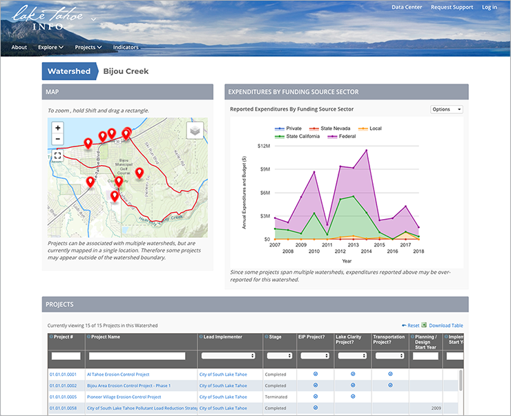
We designed the Lake Tahoe Info platform to serve the wide range of needs among this large and diverse group of stakeholders. The platform has expanded over time and now includes eight modules: the Environmental Improvement Program Project Tracker, Lake Clarity Tracker, Parcel Tracker, Transportation Tracker, Monitoring Dashboard, Sustainability Dashboard, Thresholds Dashboard, and Stormwater Tools. These modules are all served by a centralized Data Center, enabling alignment of data standards among a diverse set of data collection activities, projects, and programs in the region.
Lake Tahoe Info is a collaborative data management hub that connects people with information to improve decision-making and sustain investments in the Lake Tahoe Basin. It brings increased transparency and accountability regarding funding spent and the quantitative accomplishments to the public, while also creating efficiencies among 50+ agencies and organizations participating in “Keep Tahoe Blue.” Its array of dashboards allows users to see linkages between actions, intermediate results, and outcomes.
Today, this regional platform provides the public a window to view more than a thousand projects since 2010. It also tracks development rights, permits, and deed restrictions on over 70,000 parcels within the five counties bordering the lake.
Lake Tahoe Info has become a model system for other regional organizations to emulate. The platform has generated two open-source applications (ProjectFirma and Stormwater Tools) that are now being implemented by other public agencies, including the Washington Department of Natural Resources, Orange County Public Works, and US Bureau of Reclamation.