We combine environmental subject expertise with practical AI and machine learning capabilities that can help you unlock data, automate workflows, and make more confident decisions — faster.

Partner with ESA to cut through the hype and gain access to real-world solutions that deliver sustainable results.

How We Work

Our Approach

At ESA, we focus on the outcome, not the tool. We align technology solutions with how organizations operate to help teams leverage their data as a strategic asset. We build people-centered solutions that meet clients where they are, especially for those new to AI solutions. It’s never too late to get started.

Step 1

Define the Challenge

We start with your problem, not the tech. Working closely with your team, we do a deep dive to understand your needs, opportunities, datasets, and workflows, then apply the right solutions where they add value.

Step 2

Prove through Performance

We build a roadmap of the appropriate solutions from proof-of-concept to production. Then, we quickly create a low-risk prototype to validate accuracy and value.

Step 3

Validate with Your Expertise

Our human-in-the-loop (HITL) solutions create clear outputs backed up with confidence scores, source citations, and transparent workflows where your team actively reviews and engages in the process.

Step 4

Scale and Sustain

We scale solutions to deliver reliable, repeatable results, and provide training and post-launch advisory support.

What We Do

Solutions for Common Challenges in Environmental Data Management

Our team of 50 technologists, including data scientists, generative AI engineers, software engineers, geospatial analysts, and UI/UX designers, can help solve common challenges such as:

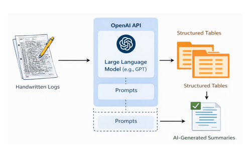
AI Strategy & Advisory Needs

Artificial intelligence (AI) is reshaping how organizations operate at an unprecedented pace. We help you understand where you are in your AI journey, identify high-impact opportunities and constraints, and develop a clear, actionable roadmap to put AI to work.

Repetitive Tasks Automation

Routine and cumbersome workflows can be error-prone and labor-intensive. With AI-enabled automation and custom machine learning models, referred to as Agentic AI, we enable structured, efficient, and verifiable methods so you gain more time for higher-valued work.

Unlock Data

Essential information can be fragmented and buried in paper files, scanned PDFs, or unwieldy repositories. Large volumes of data take too much time to sift through. Using AI and machine learning integrations, we help extract, classify, and synthesize data into functional assets.

Intelligent Document Workflows

Turn lengthy, complex documents into structured, trustworthy data sources with minimal manual effort. We create systems that can read, interpret, and process documents the way a person in your organization would, but faster and with built-in checks.

Remote Sensing and Geospatial Analysis

Machine learning and neural network structures can supplement and refine geospatial and remote sensing analysis for large-scale monitoring programs. These tools help analyze satellite imagery for applications such as habitat classification, land cover change detection, and vegetation assessment, as well as process continuous data streams from remote sensor networks, including water quality monitoring.

Data Science and Predictive Analysis

Datasets can be massive, complex, incomplete, and span multiple scales, which makes them difficult to interpret and analyze. AI models can assist with trend analysis and forecasting for datasets such as climate and meteorological data, hydrologic or water quality data, and observation-based biodiversity and habitat surveys.

Proof Points

Outcomes Realized

Beacon® AI-Assisted Commitment Parsing

Case
Study
1

The Problem

Large infrastructure projects generate thousands of environmental commitments across permitting, environmental review, and construction phases. Translating those commitments from dense regulatory documents into a trackable, auditable system of record required intensive manual effort — copying text from PDFs, manually categorizing obligations, and managing revisions over multi-year project timelines.

Outcome

We embedded an AI-assisted commitment parsing capability into Beacon, ESA’s compliance platform. The system reads environmental approval documents and uses LLM-based extraction to pull commitment titles, identifiers, and timing requirements, structuring them into searchable, trackable records. Users review and confirm AI-generated suggestions, which retain links back to source documents. The result is a transparent, auditable workflow that keeps experienced professionals in control.

30–40% Manual document review time reduced
100% Traceable back to source document
Live Deployed in production

The Problem

Decades of critical groundwater data were locked in thousands of scanned Well Completion Reports — semi-structured documents spanning 80 years in varied formats, including handwritten records. The data was essential for basin-scale groundwater modeling and California Sustainable Groundwater Management Act (SGMA) compliance, but the cost and time of manual extraction was not feasible.

Outcome

For the Merced Irrigation-Urban Groundwater Sustainability Agency, we built a cloud-based machine-learning pipeline on Microsoft Azure Document Intelligence Studio to extract and geolocate well addresses, parcel numbers, and lithology descriptions from over 10,000 Well Completion Reports (WCR). Building on those results, we expanded the approach for the Yolo Subbasin Groundwater Agency — refining classification and model training to extract lithologic and well construction data from approximately 13,000 additional records. The outcome is a reusable, documented Python pipeline applicable across California basins with legacy WCR archives.

12k+ WCRs processed across two agencies
95.5% Usable data extraction rate
>100,000 Lithographic intervals extracted

The Problem

Water Quality Management Plans (WQMPs) are the backbone of stormwater compliance — but each one can run hundreds of pages of dense technical language. Agencies managing large WQMP portfolios had no efficient way to extract comparable structured data across documents. Manual entry was slow, inconsistent, and difficult to audit.

Outcome

Using the OpenAI API, we developed an extraction workflow combining prompt engineering, JSON schema mapping, and validation routines to automatically pull key WQMP attributes — site characteristics, treatment types, Best Management Practices (BMP) selections — directly from PDF files. The system assigns confidence scores and cites the source page and paragraph for each extracted data point. Client reviewers verify results within the platform interface, maintaining accuracy and verifiability.

100+ Pages processed per WQMP
100% Source-cited extraction output
Live PoC Deployed in platform

The Problem

Large-scale environmental monitoring programs including habitat assessments, land cover surveys, and vegetation mapping have historically required extensive manual interpretation of aerial and satellite imagery. At watershed or corridor scale, manual methods are too slow and inconsistent to support near-real-time environmental management decisions.

Outcome

ESA’s geospatial team applies machine learning and deep learning models including convolutional neural networks trained on multi-spectral satellite imagery, to automate habitat classification, land cover change detection, and vegetation condition analysis. Output is delivered through interactive web applications and GIS environments, enabling managers to track conditions over time, flag anomalies, and prioritize field verification. Our pipeline supports Planet, Sentinel, and Maxar sensor platforms.

20 Geospatial experts
>500,000 Acres classified
12+ Projects completed

The Problem

ESA’s Groundwater Accounting Platform (GAP) is a powerful tool for California Sustainable Groundwater Management Act (SGMA) compliance data management, but accessing its analytical depth required programming skills that many groundwater scientists and agency staff didn’t have. We wanted to demonstrate that AI could democratize access to complex environmental data tools.

Outcome

We hosted ESA’s first AI-led coding hackathon — bringing together participants with little or no coding background to interact with the GAP API using Google Colab and Gemini AI as a virtual coding teammate. In two hours, five project teams developed working data applications: correlating evapotranspiration and land subsidence, screening fields for fallowing potential, benchmarking per-parcel water use, and flagging potentially unreported wells.

5 Working prototypes built on the day
2 hrs. From brief to functional prototype
20 Non-coders building data tools

Get in Touch

Ready to get started? Start a conversation.

If you’re facing a data or workflow challenge and aren’t quite sure where AI fits, we’re here to help you think it through.

Our Team

Get to Know Us

News & Ideas