Why does this project matter?
With this funding, the State of California is planning to build a critical fast-speed internet network spanning more than 10,000 miles statewide. Some 460 miles of the project are proposed for the state’s Coastal Zone, within the California Coastal Commission’s jurisdiction. This portion of the project is referred to generally as the Coastal Middle-Mile Broadband Network (Coastal MMBN project).
What is ESA doing to help?
SB 156 exempted the project from CEQA, but not from other environmental regulatory permitting requirements, such as Coastal Development Permits from the California Coastal Commission or coastal local governments with certified Local Coastal Programs. These agencies typically rely upon project CEQA documentation for the environmental impact analysis needed to support their permit application review. To fill this information gap, the California Coastal Commission hired ESA to prepare a detailed Coastal Resources Assessment Report and accompanying webGIS dashboard.
The Coastal Resources Assessment Report addresses each key Coastal Act policy topic (e.g., public access and recreation; water quality, coastal waters, wetlands, and environmentally sensitive habitat areas; visual and scenic resources; and cultural and paleontological resources, among others). For each topic, the report describes the setting, analyzes potential resource impacts and associated Coastal Act policy conflicts, and recommends avoidance and minimization measures designed to resolve those conflicts.
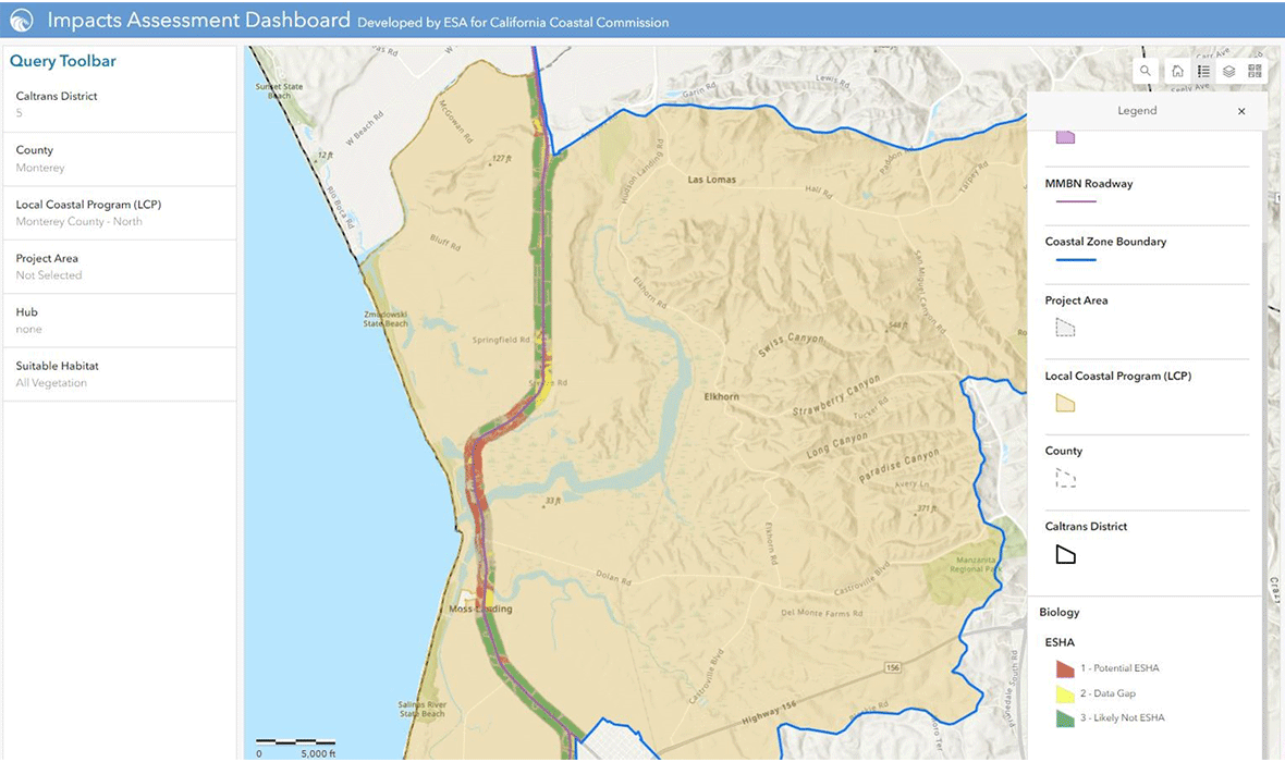
The webGIS dashboard includes a large volume and variety of geospatial data related to the project and the above listed Coastal Act policy topics. The resulting data set is the first of its kind and will be essential to Commission staff’s timely review of potential project effects. The dashboard includes pre-programmed queries that allow Coastal Commission staff to conduct their own analysis of potential project effects on key coastal resources across various geographic scales.
ESA’s work was completed within the client’s expedited one-year schedule to comply with funding requirements. This work was recently recognized by the Association of Environmental Professionals’ (AEP) which selected the Coastal Resources Assessment Report and webGIS dashboard for its 2024 Outstanding Environmental Analysis Document Award. The Coastal Commission’s first of several anticipated permits relying upon ESA’s work was approved in March 2024.