The internet has grown increasingly essential to many aspects of our daily lives—we rely on it for work, school, entertainment, connection, and shopping. While our economy and society grow ever-more internet dependent, the digital divide expands.
Access to reliable, high-quality internet is lacking throughout the U.S., with rural and remote communities requiring new broadband infrastructure investments. In California, the state’s Department of Technology published a Draft Digital Equity Plan last year showing that one out of five residents lack access to affordable, reliable broadband service.
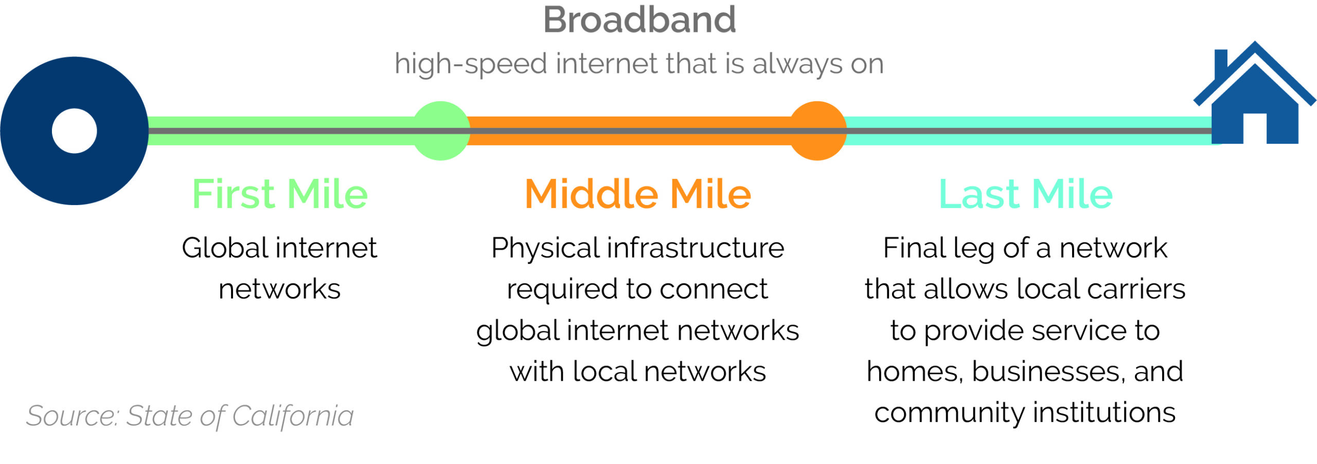
The State of California has been working to change that. Governor Newsom’s approval of Senate Bill 156 (SB 156) in 2021 allocated $3.25 billion in funding in support of an unprecedented broadband installation effort called the Middle-Mile Broadband Initiative.
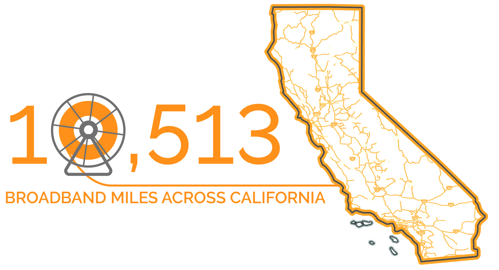
The size and scope of this effort is mind-boggling, and it’s the first of its kind. When complete, the Middle-Mile Broadband Network (MMBN) will involve a whopping 10,513 miles of linear broadband installation across all of California’s 58 counties. To put it in perspective, if laid out in one long line, that’s enough broadband to reach more than a third of the way around the world.
In support of this massive project—significant in both its contribution to equitable access to reliable internet connectivity and its tremendous scale—ESA provided environmental consulting services, including a statewide programmatic biological assessment that encompassed the full project and a separate effort focused on specific considerations for the state’s coastal zone.
A 10,000-Mile View: The Statewide Programmatic Biologic Assessment
SB 156 exempted the project from the California Environmental Quality Act’s (CEQA’s) detailed environmental review requirements. However, the project is still required to comply with other federal, state, and local environmental laws and regulations. For example, the federal Endangered Species Act (FESA) protects fish, wildlife, and plants identified by the federal government as threatened or endangered, along with their designated critical habitat. Compliance with FESA typically involves preparation of a site-specific biological assessment. To help expedite the project’s FESA compliance obligations, ESA developed a statewide programmatic biological assessment, covering all 10,500 miles of the project alignment.
“It’s really unique—the project is touching all parts of California, from desert to redwoods and everything in between,” says Jon Waggoner, ESA’s lead biologist, who brings decades of experience with fiber optic cable installations.

“This is probably the largest programmatic biological assessment in quite a few years, crossing so many landscapes ecosystems in a really biodiverse state.”
Jon Waggoner, Environmental Compliance Program Manager
The list of endangered species—plants, animals, and fish—that call California home is upward of 250 and climbing. To provide quantitative information about the potential impacts the broadband installation would have, ESA biologists teamed up with U.S. Fish and Wildlife Service (USFWS) and California Department of Transportation (Caltrans) staffs to determine the best approach for a comprehensive study.
Together, this team developed an analytical model that spanned the anticipated project installation corridor, compiled the best available vegetation data from state and federal databases, and identified potentially affected species based upon the mapped vegetation communities. By overlaying multiple datasets, the team was able to get an expansive view of the project’s potential species and habitat impacts and, in turn, create conservation measures to address such impacts. Along the way, the USFWS supplemented the team with regional specialists to best address many habitats and landscapes.
By approaching FESA compliance with a comprehensive study, ESA provided Caltrans and the USFWS with the tools—including an interactive online database (more on that later)—necessary to maintain the project’s expedited schedule while ensuring appropriate measures are applied during construction to protect threatened and endangered species and their habitats.
Next Up: Making Sure the Coast Is Clear
The California Coastal Commission is the agency charged with planning and management of the state’s diverse coastal resources. Projects proposed within their jurisdiction, known as the “coastal zone,” typically require a coastal development permit.
Approximately 456 miles of MMBN facilities are proposed within the coastal zone. Coastal Commission staff typically draw upon a project’s CEQA document to help inform their coastal development permit application review. However, because SB 156 exempted the MMBN from CEQA review, no such document is available.
To support the project’s permit review, ESA, in collaboration with Coastal Commission staff and Dr. Charles Lester (former executive director of the Coastal Commission and coastal policy expert), prepared a CEQA-like assessment of potential project effects on coastal resources.
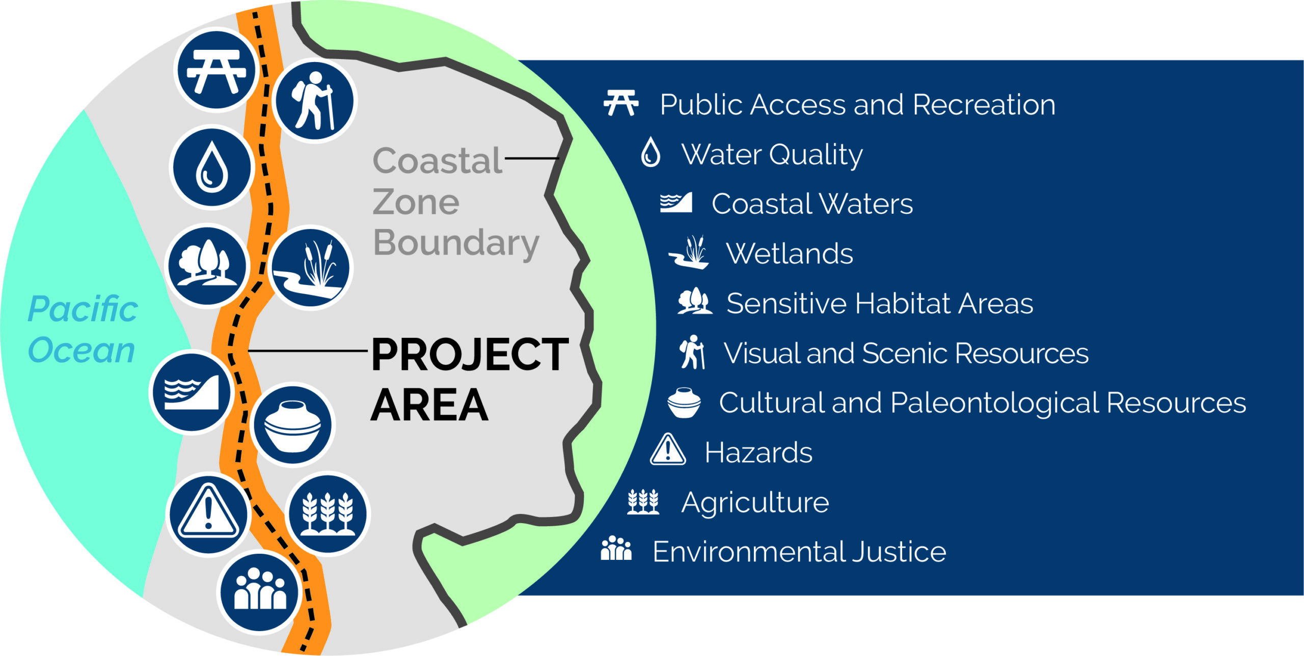
The study, which involved extensive geospatial data collection and analysis, covered the range of topics the Coastal Commission typically considers when reviewing development proposals, including potential impacts to sensitive species and habitats, wetlands, public access and recreation, visual and scenic resources, cultural and paleontological resources, coastal hazards, agriculture, and environmental justice. The resulting assessment includes recommendations for measures to avoid or minimize potential project effects across these resource areas.
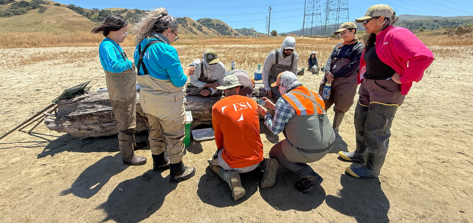
ESA’s development of a far-reaching webGIS database enabled detailed desktop analysis of potential project effects on coastal resources for most of the project alignment. However, limitations in data quality or availability for some resource areas required in-person field reconnaissance. With advance planning and multiple teams equipped with GIS-enabled tablets, the ESA team completed windshield surveys at selected sites across hundreds of miles of project alignment in one week.

“Working with the Coastal Commission to deliver this level of environmental documentation and webGIS database within one calendar year to meet the funding deadline is something our team is really proud of.”
Eli Davidian, Senior Project Manager
“Close collaboration between the Commission’s and ESA’s respective technical experts allowed us to develop this really powerful webGIS dashboard that will continue to support coastal assessments long after this project is completed,” says ESA project manager and coastal permitting expert Eli Davidian.
Added Dimension: Interactive webGIS Dashboards
To support the MMBN statewide programmatic biological assessment and coastal resources analysis reports, ESA’s GIS team developed an accompanying interactive online dashboard, presenting the myriad data collected in a user-friendly, query-enabled interface.
“This effort was big in terms of sheer volume of data, involving 85 separate data layers that needed to be reviewed, consolidated where appropriate, and overlayed to show the most relevant information for each portion of the map,” explains Suzanne Goldstein, ESA’s Northern California Geospatial Services manager, who is involved in both efforts along with a full team of GIS analysts.

This was definitely one ESA’s larger GIS efforts in terms of volume and diversity of data combined with the complexity of the analysis, and it was fun to build this dashboard tool that lets our clients leverage advanced capabilities of their established Esri environment.”
Suzanne Goldstein, Geospatial Services Manager
The coastal resources analysis dashboard allows California Coastal Commission staff to zoom through a map display or to query the system (e.g., evaluate potential impacts within a selected geography, such as a specific Local Coastal Plan area) and toggle layers to view the various resource data (e.g., Environmentally Sensitive Habitat Area (ESHA) or public accessways) along the coast—from Del Norte to San Diego County.

“ESA’s Coastal MMBN Assessment will allow for information sharing, expedited permit reviews, future project support, and environmental protection up and down the state and will ultimately support the very important MMBN project goal of improved and affordable internet access for all Californians,” says Brittney Cozzolino, Statewide Planning Supervisor for the Commission.
Increasing Access, One Mile at a Time
The MMBN installation will be completed by December 2026. ESA is poised to assist the State with any further studies or compliance monitoring that may be required. If you would like to learn more about this project or our ability to provide construction compliance services, please email Jon Waggoner, Eli Davidian, or Suzanne Goldstein.