Stormwater Tools™
Operationalize BMP Asset Management to Improve Watershed Health
Regional and municipal water managers across the country are turning to web applications to support stormwater management programs. Stormwater Tools meets this need with specialized tools for Best Management Practices (BMP) asset management and watershed planning. While assets and associated observations may vary by region, common data management objectives do not. These objectives—maintaining consistent BMP asset inventories across jurisdictions, rapidly assessing BMP condition, tracking maintenance activities, and determining the performance of BMP assets relative to Total Maximum Daily Load (TMDL) and watershed plan requirements—are the core building blocks of the Stormwater Tools web application.
Stormwater Tools is an open-source platform built by ESA in collaboration with Geosyntec. This platform is designed to serve both permittees and regulators. For permittees, it provides reliable, watershed-specific estimates of volume and pollutant loading, helping permittees anticipate problems before they happen and build trust with their citizens. For regulators, it provides accurate, reliable, and highly accessible quantification and estimation of stormwater volumes and pollutants that supports attainment of water quality standards.
Is Stormwater Tools a fit for your organization?
Yes, if you are designing and implementing a Storm Water Management Plan (SWMP) as an NPDES MS4 permittee
Yes, if you are monitoring for pollutant loading (TDMLs) and On-Land Visual Trash Assessments (OVTAs)
Yes, if you are tracking inventories and maintenance for stormwater Best Management Practices (BMP) assets
The Stormwater Tools web application is perfectly suited for multi-jurisdictional collaboration while facilitating inter-operability with other data systems. The platform includes the Inventory Module, Trash Module, and Modeling Module.
Benefits
- Foster Collaboration: Establish a centralized source of shared data for regional stakeholders
- Improve Analysis: Quickly Assess BMP performance and delineate catchment areas
- Guide Planning: Model stormwater pollutant loading scenarios to compare water quality improvement strategies
Stormwater Tools Features
Stormwater Tools features a complete set of tools to meet the needs of both stormwater permittees and regulators.
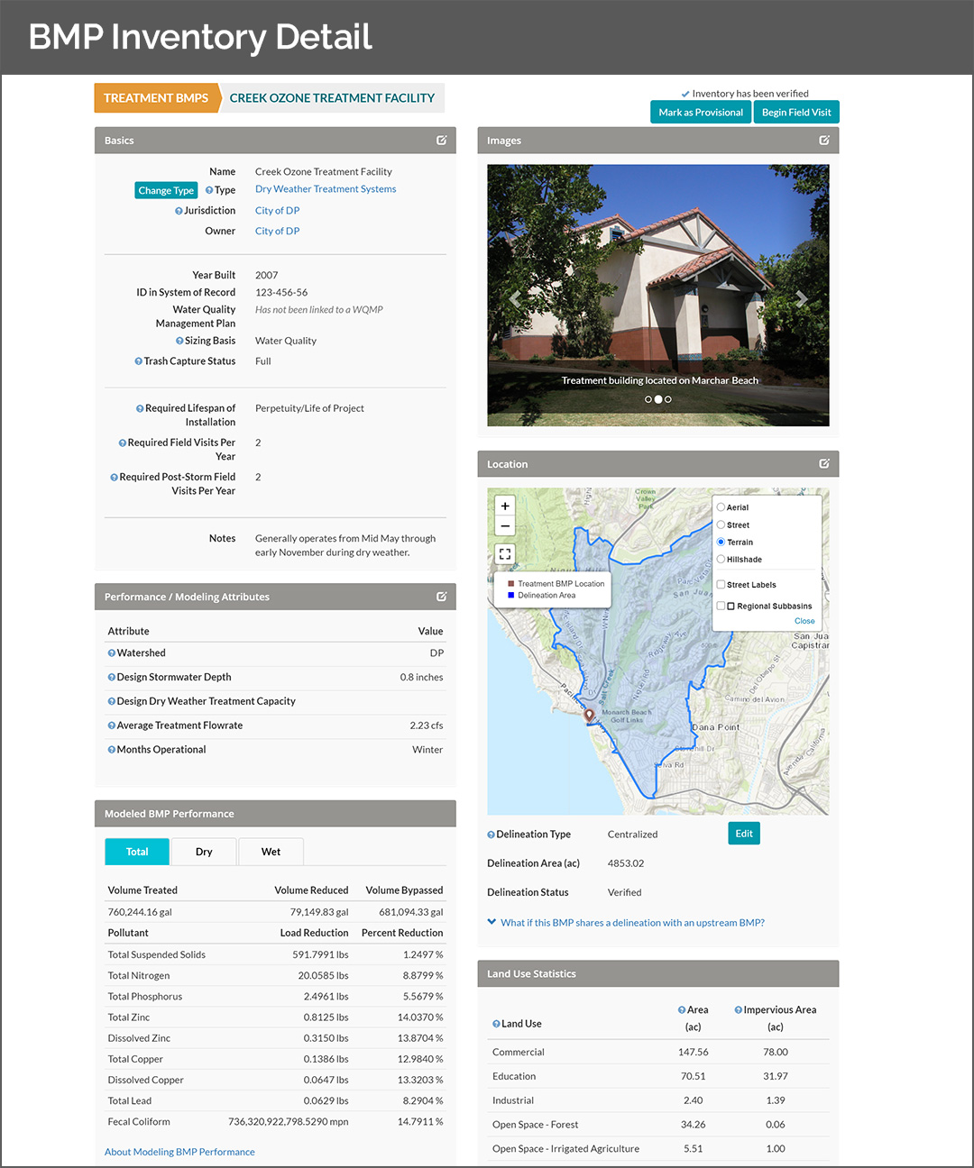
Track Best Management Practices Assets (e.g., swales, ponds, filtration devices, and infiltration basins) and get automated BMP condition scores
Record rapid visual assessments
Prioritize and track maintenance activities
Support watershed delineations with fully integrated geospatial analysis
Supports both desktop and mobile workflows including field-optimized workflows to collect BMP photos and attributes
System administrators are able to configure and add BMP types, attributes, benchmarks, thresholds, and weighting
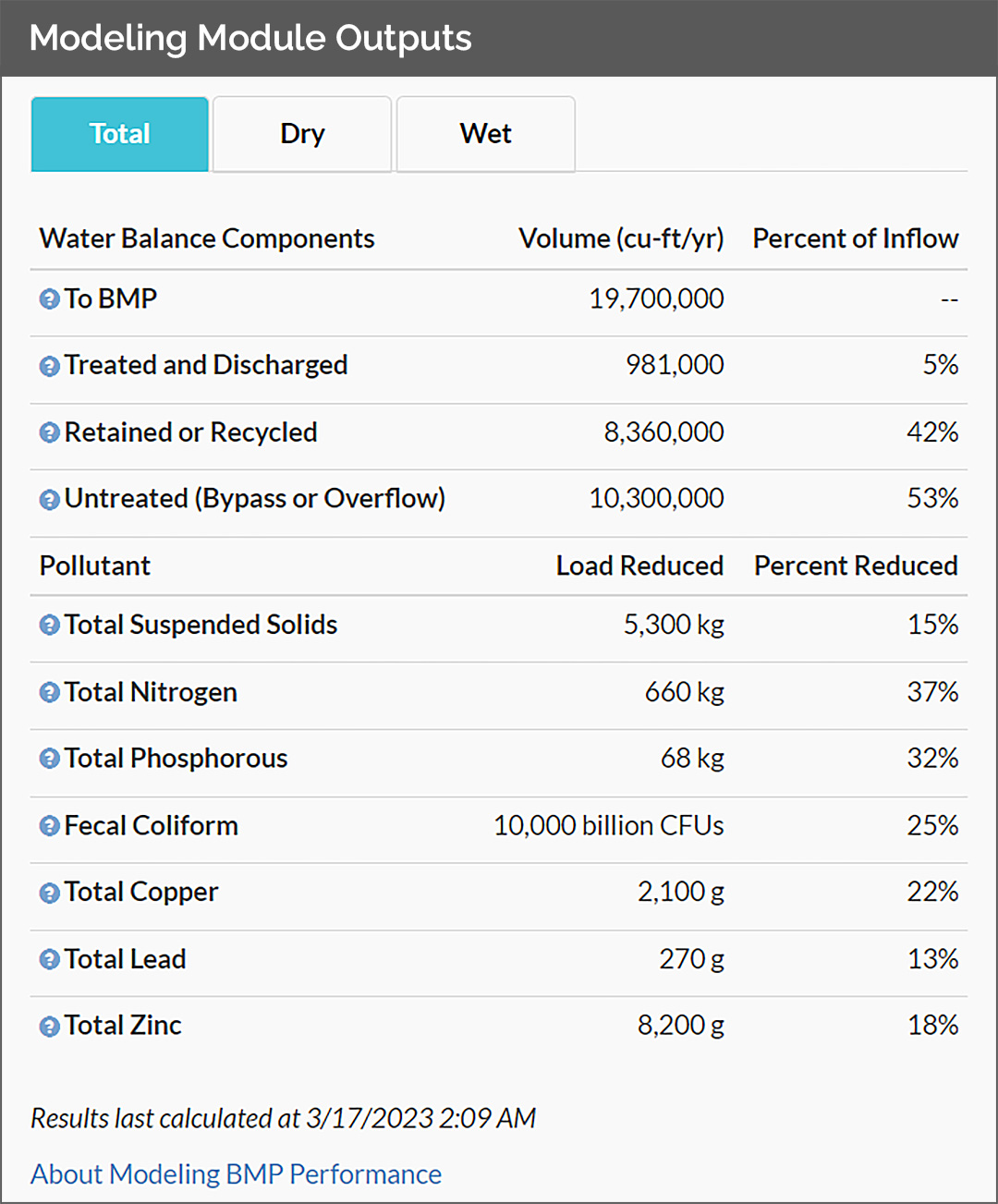
Quantify stormwater capture and pollutant load reduction directly from BMP inventory and development sites
Produce reliable and repeatable performance estimates
The modeling engine, built by our partners Geosyntec and operated by ESA, performs calculations leveraging data for catchments, BMPs, and flow paths to automatically recalculate results as users update the asset inventory
Calculations account for the cumulative benefit of nested stormwater treatment facilities
Automatically calculate the subset of the watershed affected by an asset inventory update
Quantify urban runoff captured during dry and wet weather
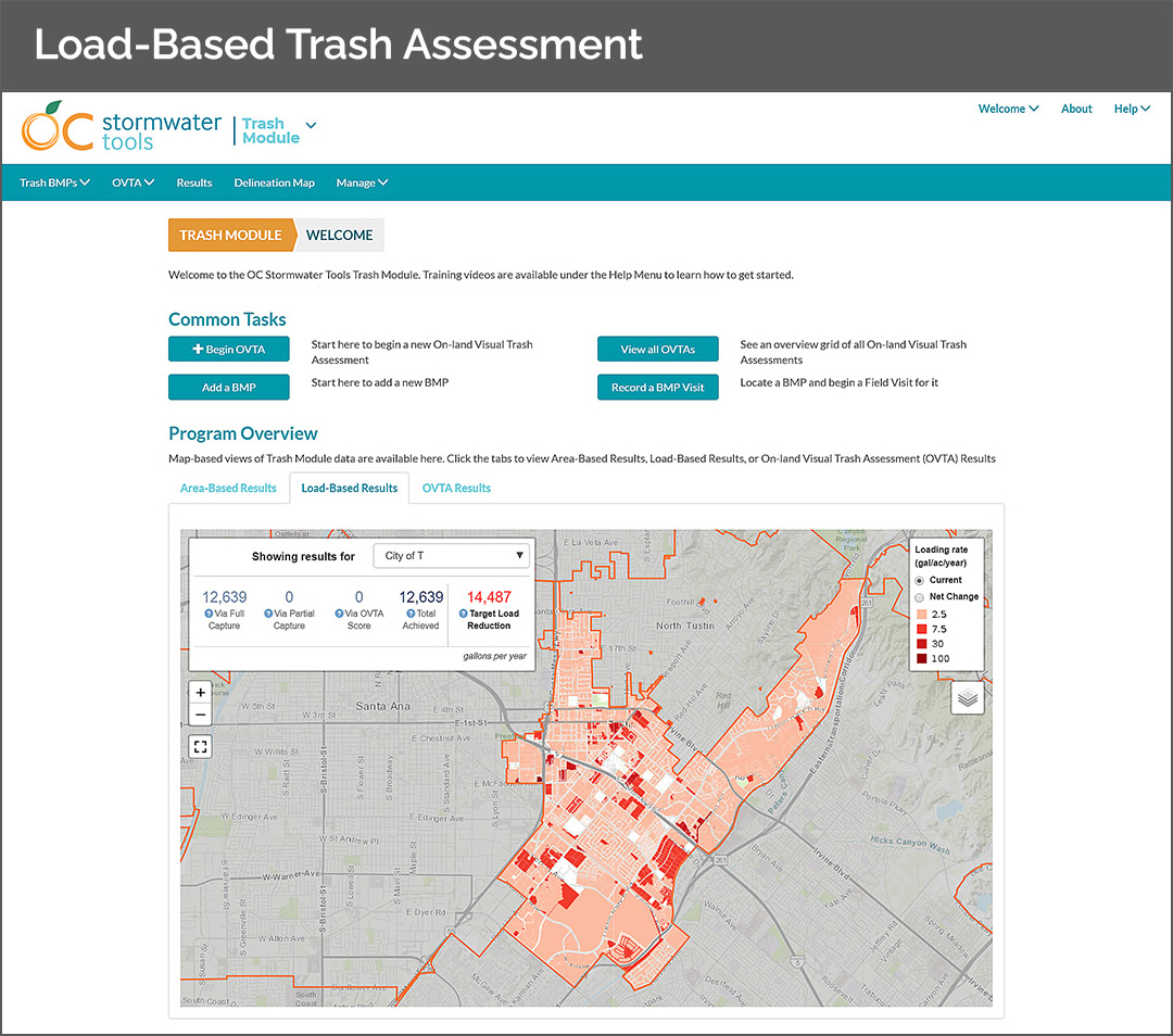
Record On-land Visual Trash Assessments (OVTAs)
Determine progress towards trash reduction goals in real-time
Combine asset information with GIS mapping resources
Track progress towards compliance with TMDLs
Assign attributes to inventoried BMPs
View current progress reports in multiple ways, including Area-Based (priority land use acres), Load-Based (gallons per year), and OVTAs (acreage of full capture equivalent)
“The Lake Tahoe Info Stormwater Tools software is alarmingly intuitive!”
Jason Burke | Stormwater Program Coordinator, City of South Lake Tahoe
Stormwater Tools Clients

Planning Agency

Public Works


Environmental Protection
Conservation District


